 History
Disasters, War, ...
Tsunamis
History
Disasters, War, ...
Tsunamis
| Don's Home
History
Disasters, War, ...
Tsunamis
| Contact |
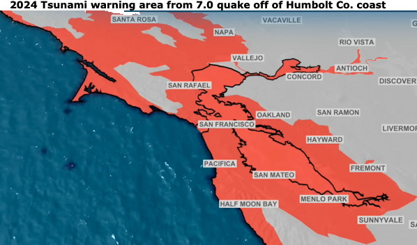
In 2024 a 7.0 Earthquake 7 miles of the coast in Humboldt Co California caused a phone warning U.S. Tsunami Warning System | NOAA / National Weather Service and notification of emergency managers and other local officials, the public, and other partners about the potential for a tsunami following a possible tsunami-generating event. People throughout north western California got the notices over their phones from the National Weather Service .
An evacuation order was issues for west Berkeley.
What ato do:
Some Facts about Tsunamis:
Deep Ocean:
 Speed: 300-600 MPH
 Height: A few inches to 3 ft.
 Period: 5 minutes - 2 hr.
 Wave Length:
   Earthquake generated: 12 - 180 mi. (20 - 300 km.)
   Landslide generated: 200 yards - 20 mi.
Near Shore:
 Speed: 15-20 MPH
 Height: 10 to 100 feet
Wind-driven waves typically reach 10 metres. However, these waves only involve water close to the ocean surface and are separated by at most several hundred metres with a period of 10 sec.
Tsunami waves have a very deep reach, 4000 metres or more with a wave length of 3-500 miles. They involve the entire depth of the ocean. Their energy is thousands of times more than a monster storm.
Because the rate at which a wave loses its energy is inversely related to its wave length, tsunamis not only propagate at high speeds, they can also travel great, transoceanic distances with limited energy losses.
Tsunamis do not necessarily make their final approach to land as a series of giant breaking waves. They may be more like a very rapidly rising tide. This may be accompanied by much underwater turbulence, sucking people under and tossing heavy objects around. Entire beaches have been stripped away by tsunamis.
Information at NOAA's (National Oceanic and Atmospheric Administration) StormReady.com:
There were 21 damaging Tsunamis and 76 non-damaging Tsunamis from 1990-1999
Tsunamis with the highest death toll:
| Deaths | Year | Location | Notes |
|---|---|---|---|
| 19,759 | 2011 | Tohoku Japan | The 9.0-9.1 earthquake was the largest ever recorded in Japan and the third-largest in the world since 1900. Following a major earthquake, a 15-metre tsunami disabled the power supply and cooling of three Fukushima Daiichi reactors, |
| 225,000 | 2004 | Indian Ocean | 9.0 Earthquake near Sumatra, Indonesia, affecting more than 10 countries in SE Asia and NE Africa. Sri Lanka, India, and Indonesia were worst hit. Waves were 8 to 20 ft. |
| 131 | 1964 | Alaska | 9.2 Earthquake. The earthquake triggered a tsunami with waves reaching up to 70 meters in height. Tsunamis reached as far away as Crescent City, California |
| 83,000 | 1908 | Messina, Italy | 7.5 Earthquake |
| 70,000 | 1755 | North Atlantic - Lisbon, Portugal | 100,000 died from tsunami, earthquake and fire |
| 40,000 | 1782 | S. China Sea | Includes deaths in Taiwan |
| 36,500 | 1883 | S. Java Sea Krakatau Volcano. Tsunami over 120 ft. high | 100 K died from earthquake and tsunami. |
| 30,000 | 1707 | Tokaido-Nankaido, Japan | |
| 26,360 | 1896 | Sanriku, Japan | |
| 25,674 | 1868 | N. Chile | |
| 15,030 | 1792 | Sw. Kyushu Island, Japan | |
| 13,486 | 1771 | Ryukyu Trench | |
| 8,000 | 1976 | Moro Gulf, Philippines | |
| 5,233 | 1703 | Tokaido-Kashima, Japan | |
| 5,000 | 1605 | Nankaido, Japan | |
| 5,000 | 1611 | Sanriku, Japan | |
| 3,800 | 1746 | Lima, Peru | |
| 3,620 | 1899 | Banda Sea, Indonesia | |
| 3,000 | 1692 | Jamaica | |
| 3,000 | 1854 | Nankaido, Japan | |
| 3,000 | 1933 | Sanriku, Japan* | |
| 2,243 | 1674 | Banda Sea, Indonesia | |
| 2,182 | 1998 | Papua New Guinea | Underwater Landslide |
| 2,144 | 1923 | Tokaido, Japan | |
| 2,000 | 1570 | Chile | |
| 1,997 | 1946 | Nankaido, Japan | |
| 1,700 | 1766 | Sanriku, Japan | |
| Others of interest: | |||
| 1,000 | 1960 | South Central Chile | 9.5 Earthquake (revised from 8.6 due to new scale for large earthquakes) 61 died when the tsunami hit Hilo Hawaii. From 1,000 to 2,290 total died from the earthquake and tsunami. (Article) |
| 165 | 1946 | Hawaii | 7.5 earthquake in Aleutian Isl. caused waves over 30 ft. in Hilo, Hawaii |
| 100? | 1854 | Lituya Bay, Alaska | Wave up to 400 ft. high from landslide |
| 122 | 1964 | Gulf of Alaska | |
| 27-51 | 1929 | Newfoundland's Burin Peninsula | 7.2 earthquake causing glacial debris at the edge of Georges Bank by the St. Lawrence River to collapsed down the continental slope of North America, creating a 40-foot wave. |
You ain't seen nothing yet.
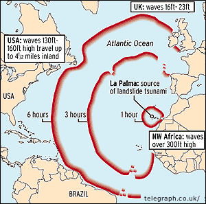 There is the possibility that any time in the next few thousand years an eruption of volcano of Cumbre Vieja on La Palma in the Canary Islands could cause a massive landslide creating a mega-tsunami which travel across the Atlantic in about 9 hours and send a 30-70 foot tall wave across the East Coast of the US from Boston to Miami and into the Caribbean traveling up to 20 miles inland.
The volcano's last eruption in 1949 made its western flank highly unstable. It could literally split apart next time the volcano erupts. It has shown no signs of activity since that eruption.
Scientists say the entire area of unstable slope may not fall at once. Instead, smaller landslides may occur over time. These landslides would produce waves one-fourth to half the height of the mega tsunami.
Monitoring might at best provide two weeks warning of the disaster.
See:
Mega-tsunami at the bbc.
Giant Wave will hit Britain at 500 MPH at news.telegraph
Cumbre Vieja Volcano -- Potential collapse and tsunami
Volcanic Landslide Could Send Mega Tsunami to U.S. East Coast at disasterrelief.org
Tsunami: Why America's Coast Would Be Toast at propagandamatrix.com.
Cracks discovered in the ocean floor just north of Cape Hatteras in North Carolina in 2004 could warn of an unpredictable disaster. The cracks, a 25-mile-long series of roof shingle-shaped ridges located 300 to 600 feet below the ocean surface may cause the seabed to crumble, creating a submarine landslide, or "slump," triggering a tsunami with waves 20-feet high in some places.
See more at:
U.S. Tsunami Warning System | NOAA / National Weather Service
Tsunami Frequently Asked Questions | NOAA National Weather Service

Timeline: Tsunami disasters at CNN
Pacific Tsunami Warning Center
Intergovernmental Oceanographic Commission (IOC)
National Geographic
Ocean Atlas
Red Cross
 International Tsunami Information Center - Library (
Tsunami Great Waves) at the  National Oceanic and Atmospheric Administration (NOAA).