Directions from Cal Alpine Lodge - 730 Panoramic Hwy to:
Pantoll Mt. Tam SP. Hqtrs. | Mount Tamalpais East Peak |
Marin Headlands Visitors Center | Fort Cronkhite | Tennessee Valley Trailhead | Mill Valley | San Francisco Airport
Mount Tamalpais SP HQ - Pantol 5 min
| 1. | Head Northwest On Panoramic Hwy | 2.9 Mi |
| Pantoll parking is on the left |
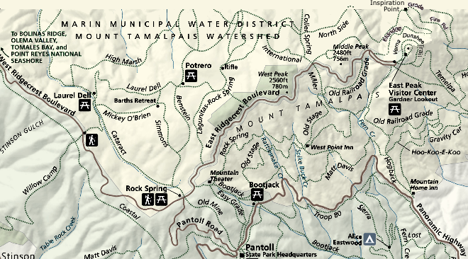
Mount Tamalpais East Peak 20 min
| 1. | Head Northwest On Panoramic Hwy | 2.9 Mi |
| 2. | Bear Right On Pan Toll Rd | 1.4 Mi |
| 3. | Turn Right On E Ridgecrest Blvd | 2.7 Mi |
Marin Headlands Visitors Center 30 min.
| 1. | Head southeast on Panoramic Hwy toward Marin View Ave | 2.5 mi |
| 2. | Turn left at CA-1/Shoreline Hwy | 3.1 mi |
| 3. | Merge onto US-101 S via the ramp to San Francisco | 4.0 mi |
| 4. | Take the exit toward Sausalito | 381 ft |
| 5. | Turn right at Sausalito Lateral | 0.3 mi |
| 6. | Slight left at Bunker Rd | 2.6 mi |
| 7. | Continue on Field Rd | 0.1 mi |
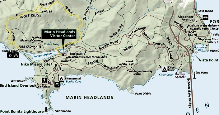
Fort Cronkhite 30 min.
Short way 30 min.
| 1. | Head towards the Marin Headlands Visitors Center, Steps 1-6 above. |
| 2. | Right on Bunker Rd. across Rodeo Lagoon | 0.5 mi |
| 3. | Continue towards ocean on Mitchell Rd | 0.2 mi. |
| 4. | Right on Assburn St. - Parking on right |
Long (scenic) way (Via Conzelman Rd.) 35 min.
| 1. | Head southeast on Panoramic Hwy toward Marin View Ave | 2.5 mi |
| 2. | Turn left at CA-1/Shoreline Hwy | 3.1 mi |
| 3. | Merge onto US-101 S via the ramp to San Francisco | 4.0 mi |
| 4. | Take the exit toward Sausalito | 361 ft |
| 5. | Slight left at Sausalito Lateral | 266 ft |
| 6. | Sausalito Lateral turns slightly right and becomes
Golden Gate Recreation Area
Battery Spencer and Kirby Cove trail is here. | 0.2 mi |
| 7. | Continue on Conzelman Rd
Point Bonita lighthouse trail parking here. | 3.5 mi |
| 8. | Turn right toward Field Rd | 161 ft |
| 9. | Turn right at Field Rd | 0.6 mi |
| 10. | Turn left at Golden Gate Recreation Area
Marin Headlands Visitors Center | 144 ft |
| 11. | Slight left at Bunker Rd | 0.4 mi |
| 12. | Continue on Mitchell Rd | 0.2 mi |
| 13. | Turn right at Assburn St
Fort Cronkhite parking is on the right |
Google map
Tennessee Valley trailhead at Miwok Livery 20 min.
| 1. | Head southeast on Panoramic Hwy toward Marin View Ave | 2.5 mi |
| 2. | Turn left at CA-1/Shoreline Hwy | 2.1 mi |
| 3. | Turn right at Laurel Way
or continue another mile on CA-1 and turn right
at Tennessee Vly. Rd. | 0.1 mi |
| 4. | Turn left at Marin Ave | 0.3 mi |
| 5. | Turn left to stay on Marin Ave | 0.1 mi |
| 6. | Turn right to stay on Marin Ave | 302 ft |
| 7. | Continue on Tennessee Valley Rd | 1.6 mi |
Mill Valley 15 min.
| 1. | Head southeast on Panoramic Hwy toward Marin View Ave | 1.7 mi |
| 2. | Turn left at Sequoia Valley Rd and follow the yellow reflectors | 0.7 mi |
| 3. | Turn right at Walsh Dr | 0.1 mi |
| 4. | Slight right at Edgewood Ave | 0.7 mi |
| 5. | Slight right at Molino Ave | 0.4 mi |
| 6. | Turn left at Montford Ave | 0.1 mi |
| 7. | Turn left to stay on Montford Ave | 0.1 mi |
You will be at Miller Ave. the main drag.
Go left for downtown (Peet's coffee, the Depot)
Go right for Whole Foods, Safeway, Starbucks
San Francisco Airport 50+ min.
| 1. | Head southeast on Panoramic Hwy toward Marin View Ave | 2.5 mi |
| 2. | Turn left at CA-1/Shoreline Hwy | 3.1 mi |
| 3. | Merge onto US-101 S via the ramp to San Francisco
Over the Golden Gate Bridge | 6.3 mi |
| 4. | Exit onto CA-1, thru Dogulas McArthur tunnel
onto Park Presido Blvd, thru Golden Gate Park continue on
19th Ave.
merge onto Junipero Serra Blvd and merge with I-280 | 9.1 mi |
| 5. | Continue on I-280 S (signs for I-280/San Jose) | 4.2 mi |
| 6. | Take the exit onto I-380 E toward US-101 | 1.5 mi |
| 7. | Take the CA-101/US-101 exit toward San Francisco/San Jose | 0.7 mi |
| 8. | Keep right at the fork | 0.7 mi |
| 9. | Keep right at the fork | 0.2 mi |
| 10. | Keep left at the fork | 0.4 mi |
| 11. | Continue straight | 0.1 mi |
last updated 5 June 2009
|
