 Science
Astronomy
Universe
Celestial Coordinate System
Science
Astronomy
Universe
Celestial Coordinate System
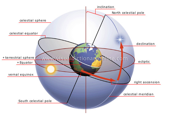
Celestial Coordinate System - a system for specifying positions of celestial objects: satellites, planets, stars, galaxies, and so on.
There are two systems for this: Azimuth and Altitude and Right Ascension and Declination.
Azimuth and altitude are probably how you would point out a star to someone. Azimuth is the angle around the horizon from due north and corresponds to the points on a compass. An azimuth of 0 degrees is due North, 90 degrees is due East, 180 degrees is due South, and 270 is due West. Altitude is the height of the star, in degrees above the horizon.
Right ascension and declination are similar to longitude and latitude. The lines similar to the longitude lines on a globe are called Right Ascension. Right ascension is measured around the celestial equator towards the east. This angle is measured in hours, minutes, and seconds. A full rotation of 360 degrees is 24 hours, so each hour of right ascension is about 15 degrees along the celestial equator. An object with a right ascension of 0 hours lies on the Vernal Equinoctal. Declination is similar to latitude and measures how far above or below the celestial equator an object is. On object below the celestial equator has a negative declination; an object on the celestial equator has a declination of zero.
Source: Physics 155: Stellar Coordinates | astronomy.uconn.edu
Source: Celestial Coordinate System - Visual Dictionary Online | visual.merriam-webster.com
Terms:
Az - Azimuth
Alt - Altitude
Celestial Coordinate System - a system for specifying positions of celestial objects: satellites, planets, stars, galaxies, and so on. More
dec or δ Declination
RA or α Right Assension
Links:
Physics 155: Stellar Coordinates | uconn.edu
RASC Calgary Centre - Right Ascension and Declination
Return to Don's Home.