 Hudson Valley
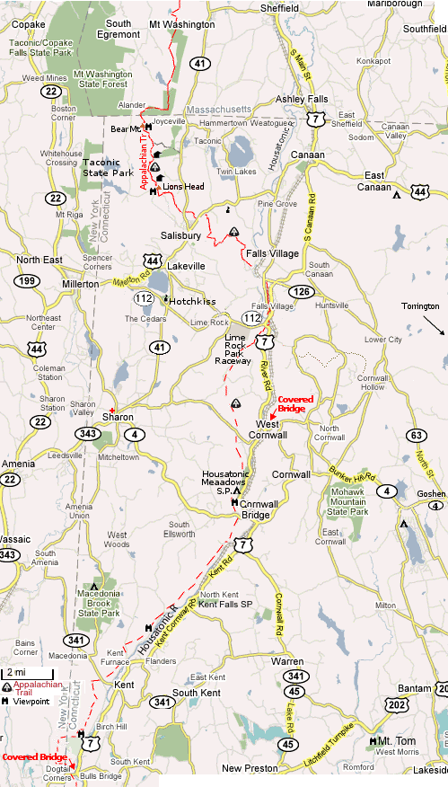 Hudson Valley | Zoom Out | Google Map
Shopping:
Radio Shack (860) 824-4554 - 89 Main St., Canaan, CT
Wal-Mart (860) 496-8653 - 970 Torringford St., Torrington, CT - 21 mi.
Costco (203) 740-7623 - 200 Federal Rd., Brookfield, CT - 36 mi.
On Hwy 7 N. of Danbury
Home Depot (860) 496-8620 - 1580 Litchfield Tpke., New Hartford, CT 22 mi.
On Hwy 202 E. of Torrington
Target (845) 336-2045 - 1300 Ulster Ave., Kingston, NY Map 28 mi.
Sporting Goods:
EMS Simsbury, CT (off Hwy 44) 31 mi., Poughkeepsie, NY 33 mi.
Backcountry Outfitters - 860.927.3377 5 Bridge St, Kent, CT 23 mi.
Clark Outdoors - (860) 672-6365 163 Route 7, W. Cornwall, CT
Terni's Store - (518) 789-3474 42 Main St, Millerton, NY - mess kits, stove gas
Gerry Cosby & Co Inc (413) 229-6600 - 03 S Undermountain Rd, Sheffield, MA 10 mi.
Spectrum Sports - 860.491.1007 400 5 1/2 Mile Rd, Goshen, CT 16 mi.
(off Bartholomew Rd. and Sucker Brook Rd. off Rt. 4
Services:
Wireless Internet: Irving Farm Coffee House, 44 Main St., Millerton, NY 518.789.2020
Skiing:
Catamount 413.528-1262 - Route 23 South Egremont, MA 10 mi.
1,000' vertical, 6 Lifts (1 quad)
Mohawk Mountain 860.485-1589 Cornwall, CT 11 mi.
640' vertical, 5 Lifts
Butternut Ski Area 413.528-2000 - Route 23 Great Barrington, MA 16 mi.
1,120' vertical, 10 Lifts (3 quads)
Sights:
Connecticut Road Trip: Enjoy the New England Charm of Litchfield Hills:
Litchfield, Mt. Tom State Park on Rt 202, Rt 341 to Kent, Continue up Route 7 to: Kent Falls State Park, West Cornwall, (a short sidetrip on 112 will take you by the Lime Rock race course and the historic Hotchkiss School at Lakeville) then to Canaan at Rt. 44 and 7.
Lion's Head in Salisbury, CT NE of Lakeville might have the distinction of being the shortest hike (4 mi round trip) with the greatest views in western Connecticut.
The Hotchkiss School
Lime Rock Park Raceway
Sharon Hospital 860.364.4141
  Emergency 860.364.4111
Lodging:
Lists at The Hotchkiss School & Lime Rock Park
Others Below:
Weather
Shopping below.
Northwest CT Convention & Visitors Bureau
Maps: Google
Distances: from Lakeville
| Place | Dist. | Time |
|---|---|---|
| Bradley Intl. Airport | 49 | 1:25 |
| Albany Airport | 72 | 1:27 |
| New York City | 112 | 2:20 |
| Hartford | 51 | 1:30 |
| New Haven | 66 | 1:40 |
| Boston | 156 | 2:50 |
(Dist. from The Hotchkiss School)
Wake Robin Inn ~ Lakeville, CT, (860) 435-2000
Interlaken Inn ~ Lakeville, CT, (800) 222-2909
White Hart Inn ~ Salisbury, CT, (800) 832-0041
The Inn at White Hollow Farm Lakeville, CT 860-435-8185 2 min
Falls Village Inn Falls Village, CT 860-824-4910 5 min
Inn at Iron Masters ~ Lakeville, CT, (860) 435-9844
Mountainside Cafe and Cabins Falls Village, CT 5 min
The Meadow House B&B Lime Rock Park, Lakeville, CT 860-248-1799
The Pines/Woodside B&B Lakeville, CT 06039 860-435-8028
Locust Tree Bed & Breakfast Canaan, CT 860-824-7163 15 min
Cornwall Inn and Restaurant Cornwall Bridge, CT 860-672-6884 10 minu
Simmons' Way Way Village Inn & Restaurant - Main Street, Rt 44 Millerton, NY 12546 Phone: (518) 789-6235
Campgrounds:

Housatonic Meadows State Park
(860) 672-6772
Cornwall,  7.31 Miles

Lone Oak Camp Sites
(860) 824-7051
360 Norfolk Rd East Canaan
9.18 Miles

Valley in the Pines Campground
(860) 491-2032
36 Lucas Rd Goshen 12.11 Miles

Macedonia Brook State Park
(860) 927-3238
159 Macedonia Brook Rd Kent
12.62 Miles

Hemlock Hill Campground
(860) 567-2267
118 Hemlock Hill Rd Litchfield,
12.93 Miles

MacEdonia Brook State Park
(860) 927-3238
Kent, CTzip code  14.00 Mile(s)

Taconic-Copake State Park
(518) 329-3993
253 State Route 344 Copake Falls
14.24 Miles
| View/ parking | Location | Miles | Dist from previous parking | Dist from parking to trail |
|---|---|---|---|---|
| P | NY-CT border Hoyt Rd. | 0 | ||
| P | Bull's Bridge | 3.8 | 3.8 | |
 | Indian Rock | 8 | ||
| P | Kent (Rt 341) Schaghticoke Rd | 11.6 | 7.8 | |
| Caleb's Peak | 15.3 | ||
| P | St. John's Ledges | 16.5 | ||
| P | Cornwall Bridge | 25.2 | 13.6 | |
| Broadloaf Mt. | 25.2 | ||
| Pine Knob | 25.5 | ||
| P | Falls Village (rt 112 & 7) | 36.2 | 11 | |
| P | Salsbury (US 44) | 44.9 | 8.7 | |
| P | Rt 41 | 45.6 | 0.7 | |
| Lion's Head | 48.3 | 2.7 | |
| P | Undermountain Trail | 50.7 | 5.1 | 2 |
| Bear Mountain | 51.6 | 0.9 | |
| CT-MA border | 52.0 |
Berkshire Hiking:
Lion's Head | Bear Mountain | Mt. Tom State Park
The Appalachian trail overview
Interactive Map - Appalachian Trail Conservancy
Topo Map of AT north of Salisbury
Connecticut chapter of the
the Appalachian Mountain Club
AT Parking, Access and Pictures: (N to S)
Mass. border to Salisbury, CT (Rt 41)
Salisbury, CT (Rt 41) to Falls Village (Rt 112/7)
Falls Village (Rt 112/7) to Cornwall Bridge (Rt 4)
Cornwall Bridge (Rt 4) to Kent (Rt 341)
Route 341 to Hoyts Road (NY border)
Links:
Other New England Pages here
Interactive Map - Appalachian Trail Conservancy
Litchfield Hills attractions at the Western CT Convention & Visitors Bureau
Return to Places