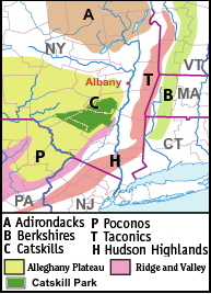
Some people define the Catskills as the four rural counties west of the Hudson River in SE New York, Green, Ulster, Sullivan and Delaware. However the area of SE Ulster county below the Shawangunk ridge is not really part of the geological Catskills and some extend them up into Albany and Schoharie Counties (I-88 on the NW and the Delaware river on the SW). See also geology.
The Catskill Forest Preserve is defined as the 286,000 acres of state land within the Catskill Park.
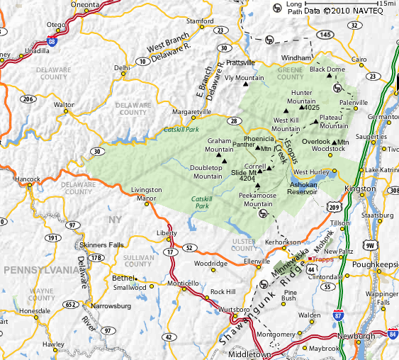
The Catskill park (green area on the map below) is bounded on the south by Beaver Kill, on the northwest by the east branch of the Delaware River, on the north by route 28 and Route 23.
Hudson Valley Maps | Larger Map
The popularity of the Catskills boomed in the 1920s through 1960s as middle class, second generation immigrant families, including Germans, Czechs, Jews, sought a place to vacation near New York City and many resorts were established in the area.
The larger Jewish resorts (such as Kutsher's, Brown's, and Grossinger's) together became known as the "Borscht Belt." A "Who's Who" of mid twentieth century comedians, such as Mel Brooks, Joan Rivers, Don Rickles and Lenny Bruce, got their start by playing the Catskills resorts.
Farther north, throughout the 20th century, more traditional large-scale resorts, country-style inns and lodges enjoyed success as well. In addition, the Catskills have long been the summer home to thousands of kids and adults attending the area's sleep-away camps.
In recent years, a few small-scale resorts have begun to return to the area, catering to outdoor adventurers and winter snow-sport enthusiasts.
See: The Catskill Mountains at Wikipedia and eHow.
Woodstock Music Festival:
In August, 1969, the Catskills were the site of a music and art festival in the town of Bethel, 43 miles southwest of Woodstock, which was the original location planned. Thirty-two of the best-known musicians of the era appeared during a sometimes rainy weekend in front of nearly half a million concertgoers.
The hit 1987 film Dirty Dancing was set in a Catskills resort in the summer of 1963 (though filmed in Virginia and North Carolina.)
Many other films were set there including scenes from Tootsie.
Sights:
Hudson Valley Sights
Catskill Park Guide
Fire tower at Overlook Mountain, Woodstock, at TravelPod (42.07831,-74.11078)
Biking:
Mohonk Preserve | Bike
Catskill Scenic Trail - 19 miles - West side of the Catskills along the West Branch of the Delaware River and New York State Routes 10 (Boomville) and 23 (Grand Gorge).
Hiking:
Hudson Valley Catskill Hiking (long trail, Appalacian Trail)
Catskill Forest Preserve at DEC.ny.gov
Minnewaska State Park
Sam's Point Preserve - Ellenville Ice Caves
Mohonk - Mohonk Trailheads
Catskill Hiking Trails at CatskillPark.com
Hiking in Catskill Park at cnyHiking.com
The Shawangunk Ridge - Delaware Water gap in NJ to Mohonk Preserve.

* Shawangunk Mountain Guide - Hiking
* gunks.com
* Wikipedia
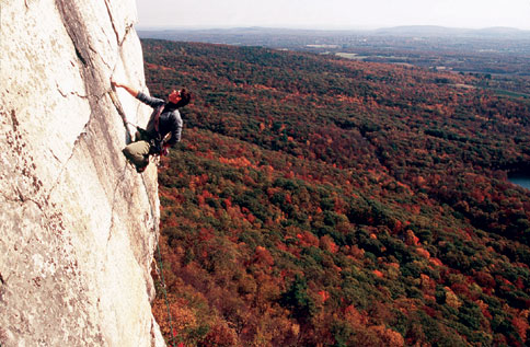
The Shawangunk Ridge, also known as the Shawangunk Mountains or The Gunks, is a ridge of bedrock, extending from the northernmost point of New Jersey toward the Hudson river near Kingston NY. It is technically the southeastern edge of the Catskill Mountains, but sometimes referred to as a separate mountain range. See Geology below.
It is a legendary eastern rock climbing site.
* Climbing the Shawangunks in Upstate New York -
* Climbing at MohonkPreserve.com
* Mohonk climbing
* Gunks Rock Climbing at Alpine Endeavors
* The Trapps (map) and Near Trapps (map) SW of the Mohonk Preserve are the two most popular areas.
* Gunks Area Info at TheUberfall.com
* The Uberfall is a climbing and bouldering site near the trapps.
Hunter
Windham
Belleayre
Fly Fishing the Esopus near Rt 28 in the Catskills west of Kingston. April 1-November 30. See FlyFishingConnection.com and Esopus Creek @ Orvis.com
Geology:
The Catskills are part of the 1 billion year old Appalachian Mountains which extend from the Canadian province of Newfoundland and Labrador in the northeast southwestward to Alabama in the U.S.
The Catskills began existence as a river delta 350 million years ago. Streams flowing off the then-mighty Taconic Mountains deposited sediment where the river met a sea (now the Allegheny Plateau. Eventually the Taconics eroded to their present size and the waters dried up, leaving a mostly flat plain.
During this time period, a meteor is believed to have struck the area. Panther Mountain is the remains of its crater.
The Pocono mountains in NE Pennsylvania are part of the same mountain range.
See: Catskill Mountains
Emergency:
Margaretville Memorial Hospital (845) 586-2631
42084 State Hwy 28, Margaretville, NY 12455 - 15 mi 20 min from Oliverea
Kingston Hospital (Health Alliance): 396 Broadway, Kingston, NY (845) 331-3131
Ulster Sheriff's Office Shandaken Sub-Station, RT 28 Allaben, NY - 688-2233
NY Department of Environmental Conservation Region 3 New Paltz - (845) 256-3000
More Maps:
Large Catskill Map
Shawangunk Senic Byway at byways.org
Shawangunk Ridge Coalition - Trail Maps
Mohonk Trailheads at
MohonkPreserve.org
Large Catskill Park (Forest Preserve)
www.dec.ny.gov/docs/lands_forests_pdf/cpslmp.pdf
Long Path:
Long Path Guide (softcopy)
Maps for the Long Path Purchase w/ a couple downloadable
Online maps
Links:
Visit New York's Catskill Mountains | Official Tourism Site of the Catskills
Visit the Catskills Mountainsn, New York Visitors Guide
Catskills - Catskillpark.com
Catskill Forest Preserve at DEC.ny.gov
Catskill Region - NYS Parks, Recreation & Historic Preservation
The Catskill Guide!
Hiking
Fishing
Shawangunk Mountains Scenic Byway - Map
The Shawangunk Ridge
Catskill Mountains at Academic Dictionaries and Encyclopedias
Hudson Valley
History of the Catskill Mountains - Wikipedia
Big Indian
Return to Places